 |
 |
 |
 |
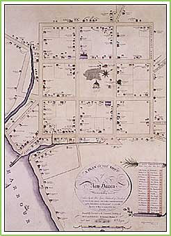
s if to herald the green itself, church bells and carillons regularly sound over New Haven's gracious and amply proportioned green in the center of town. A distinctive presence for more than 350 years, the New Haven Green not only serves as a focal point of religious, civic, and commercial activity in this coastal town on Long Island Sound, but as a relic of the oldest formally planned community in America. Settlement of the mercantile port began in 1638 by a company of English colonists who came from London via Boston under the leadership of the merchant Theophilus Eaton and the Reverend John Davenport, a Puritan minister. The new town, originally called Quinnipiac, was laid out by 1641 on a nine-square grid a plan reminiscent of ancient Roman military camps covering an area measuring a half-mile square. While the eight surrounding squares were divided into house lots, the center square was reserved for the green. This common land was the site of the first meetinghouse and a burying ground. Because New Haven was envisioned as a thriving commercial port, however, the green was also conceived as a trade center and town square, and was in fact known as "the market place" into the 1700s. It contained the town's watch house (built by 1645), the jail, and the first school, all of which are believed to have been located near the corner of present-day College and Elm streets. A series of improvements to the New Haven Green indicate that the common was regarded by townspeople as an important asset early in its history. Grass was planted by 1654, and shade trees, including elms and sycamores, were added by the 1750s. Institutional architecture was another attribute: after New Haven was declared co-capital, with Hartford, of the Colony of Connecticut in 1701, the Connecticut State House (1717) was built on the green's northwest side. |
|
|||||||||||||||||||||||||
Home | GreenLink
| Exhibits | DataCenter
© 2001–2026 TownGreens.com