 |
 |
 |
 |
Despite an attempt to sell the land to adjacent property owners in 1809, the Lebanon Green is still technically owned by the descendants of the town plot's original 51owners and their heirs and assigns (estimated to number about 650,000 people!). Because of the obvious complexity of unraveling this shared ownership, the Town of Lebanon maintains jurisdiction over the green.
|
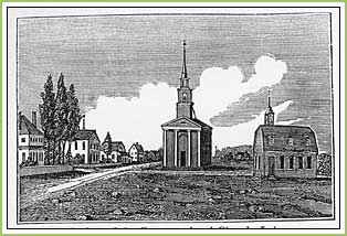
rom early settlement days the Lebanon Green was the site of the meetinghouse and school, and also served as a militia training ground and marketplace. The layout of the original house lots around the Lebanon Green is still evident from the many eighteenth- and nineteenth-century homesteads with deep, narrow farm plots melding into pasture behind the houses.
|
|||||||||||||||||||||||||||||||||||||
Home | GreenLink
| Exhibits | DataCenter
© 2001–2026 TownGreens.com